Dear parents and caregivers,
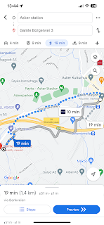
Google maps suggests that it takes19 minutes to talk from Asker station to the school. That seemed like a lot to me, so my husband and I took our youngest child, our 9 year old daughter (starting grade 4 in the fall) and tested it out. We didn't take the route suggested by google.
Route suggested by google:
We decided to walk by the "Next pharma" building, here is the walk on the map:
There are lots of routes to take, so find out what works best for you and your children.
The walk took this long from Asker station to the school:
The soon-to-be-done-with grade 3 girl got to pick the pace. Adults and MYP kids can walk faster for sure :)
Here we are by the main building, and I took pictures of the route back so you can all see:
Still smiling after the walk up, and we are now ready to walk back. We're thinking it will be faster on the way back, and she's keen to get back, so quite faster I would say....:)
Walking down the steps:
Crossing the road using the zebra crossing. We're following the walk path and will soon walk under E18.
We're on the parking lot by Next Pharma
As you can see, there isn't a walk path here, which is probably why google isn't suggesting it. But the parking space is wide.
From the parking lot by Next Pharma, there is a zebra crossing
And now we're almost at Asker station.
Definetly faster down :)
So that was our walk and our experience. I would suggest that our route is more suiteable for the older, students (maybe not grade 1 and 2), or that someone responsible walks with the younger ones. This is of course up to the parents themselves :) If you do not want to cross the car park, then just follow Google's suggestion.
Also, there is a bus stop right by the school steps too, so that's also an option of course.
Principal Robert has informed me that he will get back to all parents and caregivers how the parking/drop-off siuation will be well before school starts.
Have a lovely day!
Kristine
PC chair


.PNG)


.jpg)


